

Houston buildings flooded in the 2015 Memorial Day Floods and in the 2016 Tax Day Floods
The city of Houston has three major problems: global warming, geography and deregulation. All three problems were brilliantly illustrated by ProPublica & the Texas Tribune in their series on Houston's Flood Risk.
One article in this series, Boomtown, Flood Town, pointed out that (even before Hurricane Harvey) some parts of Houston had been flooded three times in eight years. In the last three years alone Houston has suffered from the 2015 Memorial Day Floods, the 2016 Tax Day Floods and from the flooding caused by Hurricane Harvey.
One set of regulations that builders do have to comply with are those effecting areas within the 100 year floodplain map. Unfortunately these catastrophic floods appear to be occurring nearly every year in Houston, not every century.

In response to the devastating flooding caused by Hurricane Harvey local government has been planning to tighten building regulations inside the floodplain in Harris County. Unfortunately this will do little to protect areas outside of the floodplain and as the Houston Chronicle reveals the 100 year floodplain is very out-of-date.
The 100 year floodplain is the standard used to judge flood risk. It defines areas where homes are at risk from a once in a one hundred year storm or where homes have a 1% yearly chance of flooding. However, as the Chronicle reveals, "more than 55 percent of the homes damaged during the Tax Day storm in 2016 sat outside the 500-year flood plain, as did more than one-third of those during the Memorial Day floods in 2015".
In Harvey's Floods the Houston Chronicle has mapped out the number of homes flooded inside the floodplain and the number of homes flooded outside the floodplain during Hurricane Harvey. The newspaper has done the same for the Tax Day floods and the Memorial Day floods. What all three maps reveal is that the 100 year floodplain maps are woefully out-of-date.
Major floods are occurring far more than once in a lifetime and are also affecting areas outside the current floodplain maps. The authorities are aware of the situation and are working on new maps. The new maps will be ready in 2022.
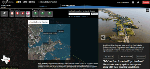
Even before Hurricane Harvey ProPublica and the Texas Tribune had created a mapped visualization exploring the dangers Houston faces from a major storm. In Hell and High Water the author's warned of the dangers Houston faced from a future hurricane.
The mapped interactive in the article simulates the likely effects of a number of potential storms on the city. Each of these simulations overlays the track of a potential storm over a satellite view of the city. These tracks are then animated to show the likely flooding events that could take place in Houston if such a storm hit the city.
No comments:
Post a Comment